South Aegean Contents Administration Major communities References External links Navigation menu36°48′N 26°12′E / 36.8°N 26.2°E / 36.8; 26.236°48′N 26°12′E / 36.8°N 26.2°E / 36.8; 26.2www.pnai.gov.gr"Demographic and social characteristics of the Resident Population of Greece according to the 2011 Population - Housing Census revision of 20/3/2014"the original"Sub-national HDI - Area Database - Global Data Lab"""The South Aegean Islands has been recognized as the European Region of Gastronomy for 2019"""Kallikratis reform law text"Official websiteee105095961221ad95f5-d3b2-4da6-99f4-92c45f64807f
AtticaCentral GreeceCentral MacedoniaCreteEastern Macedonia and ThraceEpirusIonian IslandsNorthern AegeanPeloponneseSouthern AegeanThessalyWestern GreeceWestern Macedonia
South AegeanNUTS 2 statistical regions of the European UnionStates and territories established in 1987Administrative regions of Greece
Greekadministrative regions of GreeceCycladesDodecaneseAegean SeaKallikratis planNorthern AegeanPiraeusErmoupoliSyrosprefecturesCycladesErmoupoliDodecaneseRhodesregional units
South Aegean
Jump to navigation
Jump to search
South Aegean Αιγαίου | |
|---|---|
Administrative region of Greece | |
 Flag | |
 | |
| Coordinates: 36°48′N 26°12′E / 36.8°N 26.2°E / 36.8; 26.2Coordinates: 36°48′N 26°12′E / 36.8°N 26.2°E / 36.8; 26.2 | |
| Country |  Greece Greece |
| Decentralized Administration | Aegean |
| Capital | Ermoupoli |
| Largest city | Rhodes |
| Regional units | List
|
| Government | |
| • Regional governor | Giorgos Hadjimarkos (Nea Dimokratia) |
| Area | |
| • Total | 5,285.99 km2 (2,040.93 sq mi) |
| Population (2011)[1] | |
| • Total | 309,015 |
| • Density | 58/km2 (150/sq mi) |
| Time zone | UTC+2 (EET) |
| • Summer (DST) | UTC+3 (EEST) |
| ISO 3166 code | GR-L |
HDI (2017) | 0.836[2] very high · 13th |
| Website | www.pnai.gov.gr |

South Aegean topographic map
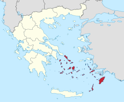
The South Aegean (Greek: Περιφέρεια Νοτίου Αιγαίου) is one of the thirteen administrative regions of Greece. It consists of the Cyclades and Dodecanese island groups in the central and southeastern Aegean Sea.
Contents
1 Administration
2 Major communities
3 References
4 External links
Administration
The South Aegean region was established in the 1987 administrative reform. With the 2010 Kallikratis plan, its powers and authority were redefined and extended. Along with the Northern Aegean region, it is supervised by the Decentralized Administration of the Aegean based at Piraeus. The capital of the region is situated in Ermoupoli on the island of Syros. The administrative region includes 50 inhabited islands, including the popular tourism destinations of Mykonos, Santorini and Rhodes. [3]
Until the Kallikratis reform, the region consisted of the two prefectures of the Cyclades (capital: Ermoupoli) and the Dodecanese (capital: Rhodes). Since 1 January 2011 it is divided into 13 regional units, formed around major islands:[4]
- Andros
- Kalymnos
- Karpathos
- Kea-Kythnos
- Kos
- Milos
- Mykonos
- Naxos
- Paros
- Rhodes
- Syros
Thira (Santorini)- Tinos
The incumbent region's governor is Giorgos Hadjimarkos.
Major communities
- Andros (Άνδρος)
- Ermoúpoli (Ερμούπολη)
- Ialysós (Ιαλυσός)
- Kallithéa (Καλλιθέα)
- Kálymnos (Κάλυμνος)
- Kárpathos (Κάρπαθος)
- Kos (Κως)
- Léros (Λέρος)
- Milos (Μήλος)
- Mýkonos (Μύκονος)
- Náxos (Νάξος)
- Páros (Πάρος)
- Petaloúdes (Πεταλούδες)
Ródos (Ρόδος) (Rhodes in English)- Santoríni (Σαντορίνη) or Thíra (Θήρα)
References
^ "Demographic and social characteristics of the Resident Population of Greece according to the 2011 Population - Housing Census revision of 20/3/2014" (PDF). Hellenic Statistical Authority. 12 September 2014. Archived from the original (PDF) on 8 September 2015..mw-parser-output cite.citationfont-style:inherit.mw-parser-output .citation qquotes:"""""""'""'".mw-parser-output .citation .cs1-lock-free abackground:url("//upload.wikimedia.org/wikipedia/commons/thumb/6/65/Lock-green.svg/9px-Lock-green.svg.png")no-repeat;background-position:right .1em center.mw-parser-output .citation .cs1-lock-limited a,.mw-parser-output .citation .cs1-lock-registration abackground:url("//upload.wikimedia.org/wikipedia/commons/thumb/d/d6/Lock-gray-alt-2.svg/9px-Lock-gray-alt-2.svg.png")no-repeat;background-position:right .1em center.mw-parser-output .citation .cs1-lock-subscription abackground:url("//upload.wikimedia.org/wikipedia/commons/thumb/a/aa/Lock-red-alt-2.svg/9px-Lock-red-alt-2.svg.png")no-repeat;background-position:right .1em center.mw-parser-output .cs1-subscription,.mw-parser-output .cs1-registrationcolor:#555.mw-parser-output .cs1-subscription span,.mw-parser-output .cs1-registration spanborder-bottom:1px dotted;cursor:help.mw-parser-output .cs1-ws-icon abackground:url("//upload.wikimedia.org/wikipedia/commons/thumb/4/4c/Wikisource-logo.svg/12px-Wikisource-logo.svg.png")no-repeat;background-position:right .1em center.mw-parser-output code.cs1-codecolor:inherit;background:inherit;border:inherit;padding:inherit.mw-parser-output .cs1-hidden-errordisplay:none;font-size:100%.mw-parser-output .cs1-visible-errorfont-size:100%.mw-parser-output .cs1-maintdisplay:none;color:#33aa33;margin-left:0.3em.mw-parser-output .cs1-subscription,.mw-parser-output .cs1-registration,.mw-parser-output .cs1-formatfont-size:95%.mw-parser-output .cs1-kern-left,.mw-parser-output .cs1-kern-wl-leftpadding-left:0.2em.mw-parser-output .cs1-kern-right,.mw-parser-output .cs1-kern-wl-rightpadding-right:0.2em
^ "Sub-national HDI - Area Database - Global Data Lab". hdi.globaldatalab.org. Retrieved 2018-09-13.
^ ""The South Aegean Islands has been recognized as the European Region of Gastronomy for 2019"". The Business Report. Retrieved 17 April 2018.
^ "Kallikratis reform law text" (PDF).
External links
 | Wikimedia Commons has media related to South Aegean. |
Official website (in Greek)
Administrative division of the Southern Aegean Region | ||
|---|---|---|
| ;_Population:_309,015_(as_of_2011) ;_Municipalities:_34_(since_2011) ;_Capital:_Ermoupoli_(Syros)">
| ||
| Regional unit of Andros |
|  |
| Regional unit of Kalymnos |
| |
| Regional unit of Karpathos |
| |
| Regional unit of Kea-Kythnos |
| |
| Regional unit of Kos |
| |
| Regional unit of Milos |
| |
| Regional unit of Mykonos |
| |
| Regional unit of Naxos |
| |
| Regional unit of Paros |
| |
| Regional unit of Rhodes |
| |
| Regional unit of Syros |
| |
| Regional unit of Thira |
| |
| Regional unit of Tinos |
| |
| ||
Administrative regions of Greece | ||
|---|---|---|
|  | |
Authority control  |
|
|---|
Categories:
- South Aegean
- NUTS 2 statistical regions of the European Union
- States and territories established in 1987
- Administrative regions of Greece


(window.RLQ=window.RLQ||[]).push(function()mw.config.set("wgPageParseReport":"limitreport":"cputime":"1.052","walltime":"1.299","ppvisitednodes":"value":4120,"limit":1000000,"ppgeneratednodes":"value":0,"limit":1500000,"postexpandincludesize":"value":77961,"limit":2097152,"templateargumentsize":"value":8708,"limit":2097152,"expansiondepth":"value":25,"limit":40,"expensivefunctioncount":"value":3,"limit":500,"unstrip-depth":"value":1,"limit":20,"unstrip-size":"value":12151,"limit":5000000,"entityaccesscount":"value":1,"limit":400,"timingprofile":["100.00% 1190.680 1 -total"," 75.57% 899.816 1 Template:Infobox_settlement"," 66.04% 786.363 1 Template:Infobox"," 15.11% 179.896 1 Template:Lang"," 8.18% 97.339 1 Template:Reflist"," 6.94% 82.628 4 Template:Cite_web"," 5.65% 67.242 2 Template:Navbox"," 4.92% 58.579 1 Template:South_Aegean"," 3.56% 42.338 1 Template:Commonscat"," 3.47% 41.360 1 Template:Convert"],"scribunto":"limitreport-timeusage":"value":"0.751","limit":"10.000","limitreport-memusage":"value":16719973,"limit":52428800,"cachereport":"origin":"mw1255","timestamp":"20190330185816","ttl":2592000,"transientcontent":false);mw.config.set("wgBackendResponseTime":102,"wgHostname":"mw1247"););


